Mining project · San Juan, Argentina

"El Fierro" Mining Project

Ten mining rights with polymetallic silver, gold, copper, lead and zinc veins in San Juan's Cordillera Frontal.

Project summary

El Fierro comprises ten mining rights owned by the Fuentes Family, covering close to 6,000 hectares at the northeastern end of the Colangüil range, Iglesia Department, San Juan. Between 2020 and February 2026, the rights were subject to an exploration agreement with a purchase option held by an international operator, which carried out geological mapping, surface sampling, geophysics and the area's first diamond drilling campaigns. The agreement ended without the option being exercised. The rights are now registered to the Fuentes Family, free of liens and third-party commitments.

Drilling results

Gold, silver and copper in the drill core

A tour of the project's 3D model: terrain, mining-right boundaries and drill holes, with laboratory grades along each hole.

El Fierro Project
Au-Ag-Cu-Pb-Zn veins
68 diamond drill holes at La Verde, Lagunitas, Antena and Fierro Bajo
LV-DH-21-08 · La Verde
3.70 m @ 11.5 g/t Au and 282 g/t Ag
Including 0.50 m @ 49.8 g/t Au from 81.4 m
LV-DH-21-19 · Lagunitas
17.7 m @ 58.6 g/t Ag and 2.1% Pb+Zn
Including 3.9 m @ 179 g/t Ag from 84.0 m
ANT-DH-22-89 · Antena
5.0 m @ 0.71% Cu, 0.20 g/t Au and 18.6 g/t Ag
Including 2.0 m @ 1.00% Cu from 60.0 m
FB-DH-21-01 · Fierro Bajo
0.50 m @ 1,290 g/t Ag and 6.9% Pb
Quartz veinlets and massive galena from 156.0 m
Grades certified by ALS
Full information in the Virtual Data Room
Drill holes, certificates, core photographs and 3D model
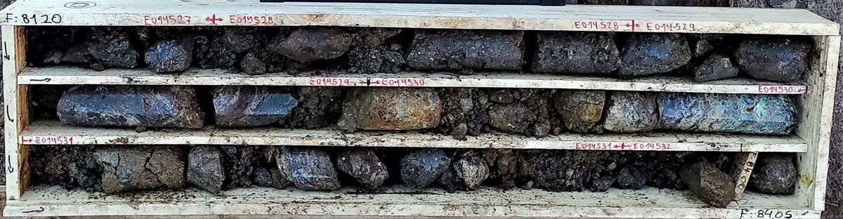
Drill core LV-DH-21-08
LV-DH-21-08 · La Verde
3.70 m @ 11.5 g/t Au and 282 g/t Ag
Including 0.50 m @ 49.8 g/t Au · from 80.9 m

Banded, crustiform quartz vein with adularia, specularite, chalcopyrite and sphalerite, hosted in volcaniclastic breccia. Pictured: box 30 (81.20–84.05 m).

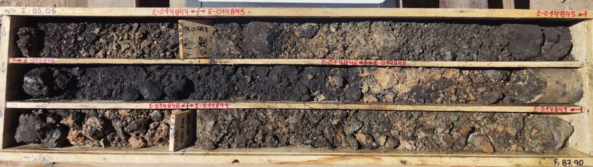
Drill core LV-DH-21-19
LV-DH-21-19 · Lagunitas
17.7 m @ 58.6 g/t Ag and 2.1% Pb+Zn
Including 3.9 m @ 179 g/t Ag · from 77.0 m

Fault breccia and vein with massive manganese and iron oxides and barite, with samples up to 314 g/t Ag. Pictured: box 33 (85.05–87.90 m).

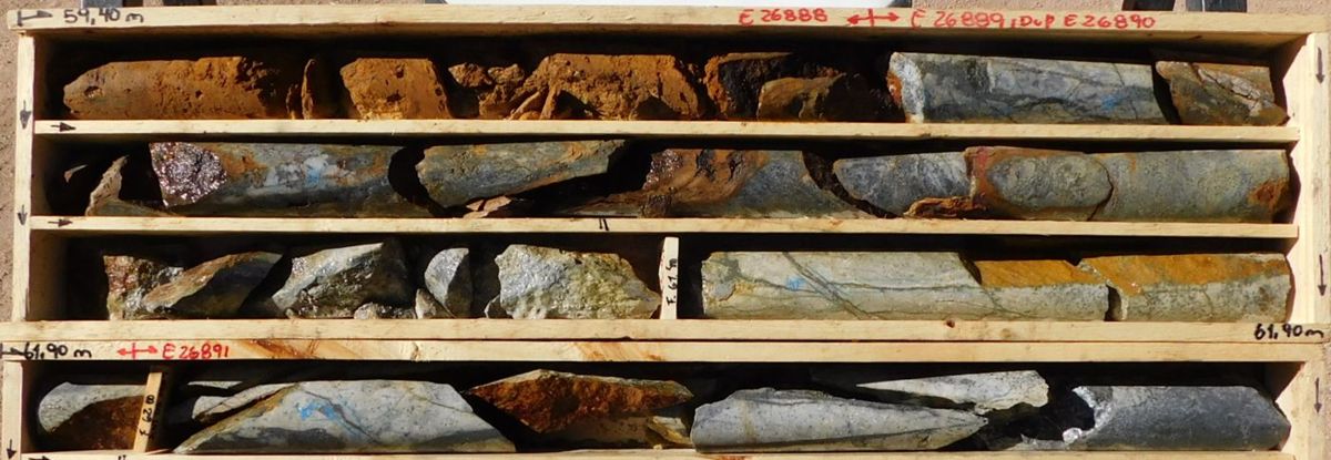
Drill core ANT-DH-22-89
ANT-DH-22-89 · Antena
5.0 m @ 0.71% Cu with 0.20 g/t Au and 18.6 g/t Ag
Including 2.0 m @ 1.00% Cu · from 60.0 m

Porphyritic rhyolite dyke with disseminated and veinlet pyrite, chalcopyrite, arsenopyrite and pyrrhotite, tourmaline and sericite-quartz alteration. Pictured: boxes 17-18 (from 59.40 m).

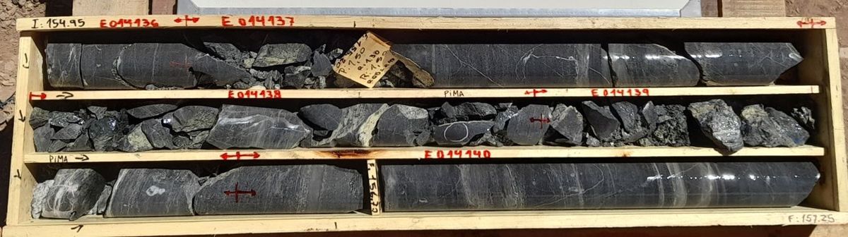
Drill core FB-DH-21-01
FB-DH-21-01 · Fierro Bajo
0.50 m @ 1,290 g/t Ag and 6.9% Pb
From 156.0 m downhole

Quartz-sericite-galena veinlets with massive galena veinlets in schist, within a fracture zone. Pictured: box 58 (154.95–157.25 m).

ALS laboratory grades, length-weighted and measured along the hole. Full details for each drill hole, the original certificates, photographs of every core box and the complete 3D viewer are available in the Virtual Data Room.

Request Data Room access

Technical overview

Polymetallic veins in four sectors

The known mineralization consists of sub-epithermal polymetallic veins. The veins are hosted in Carboniferous metasedimentary rocks and Miocene volcanics, and are controlled by northwest- to east-west-trending faults. Four sectors have been drilled: La Verde and Fierro Alto (Fierro 1), Lagunitas (Fierro 3) and Fierro Bajo (Fierro II), where the historic mines are located. About 8.8 km of vein traces have been mapped within the rights. Between 2020 and 2021, ground magnetics and induced polarization (IP) surveys were carried out over the main vein systems.

Between 2021 and 2025, 68 diamond drill holes were completed within the rights. Results publicly reported by the previous operator include hole LV-DH-21-08 at La Verde: 9.95 m grading 4.29 g/t gold and 110.7 g/t silver.

≈6,000 ha
Area of the 10 mining rights
68
Diamond drill holes within the rights (2021–2025)
9,944 m
Metres drilled within the rights
906
Rock samples, plus 2,313 soil samples
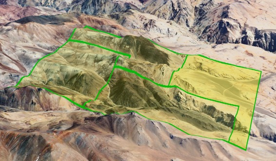
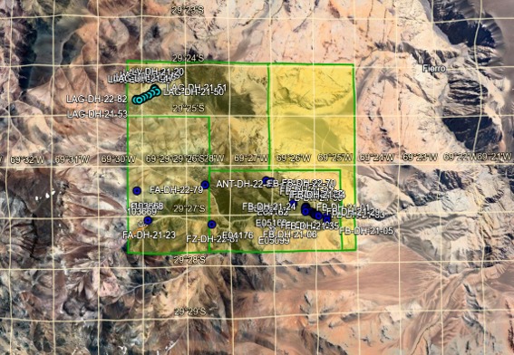
Area covered by the ten El Fierro mining rights

Area covered by the ten mining rights.

Map of drill holes and mineralized zones: Lagunitas, Fierro Alto, Fierro Bajo and Antena

Drill hole distribution across the Lagunitas, Fierro Alto, Fierro Bajo and Antena systems.

Mining history

The Rara Fortuna and Felicidad mines, part of El Fierro, were registered in 1888, within a historically mined area of the San Juan Andes.

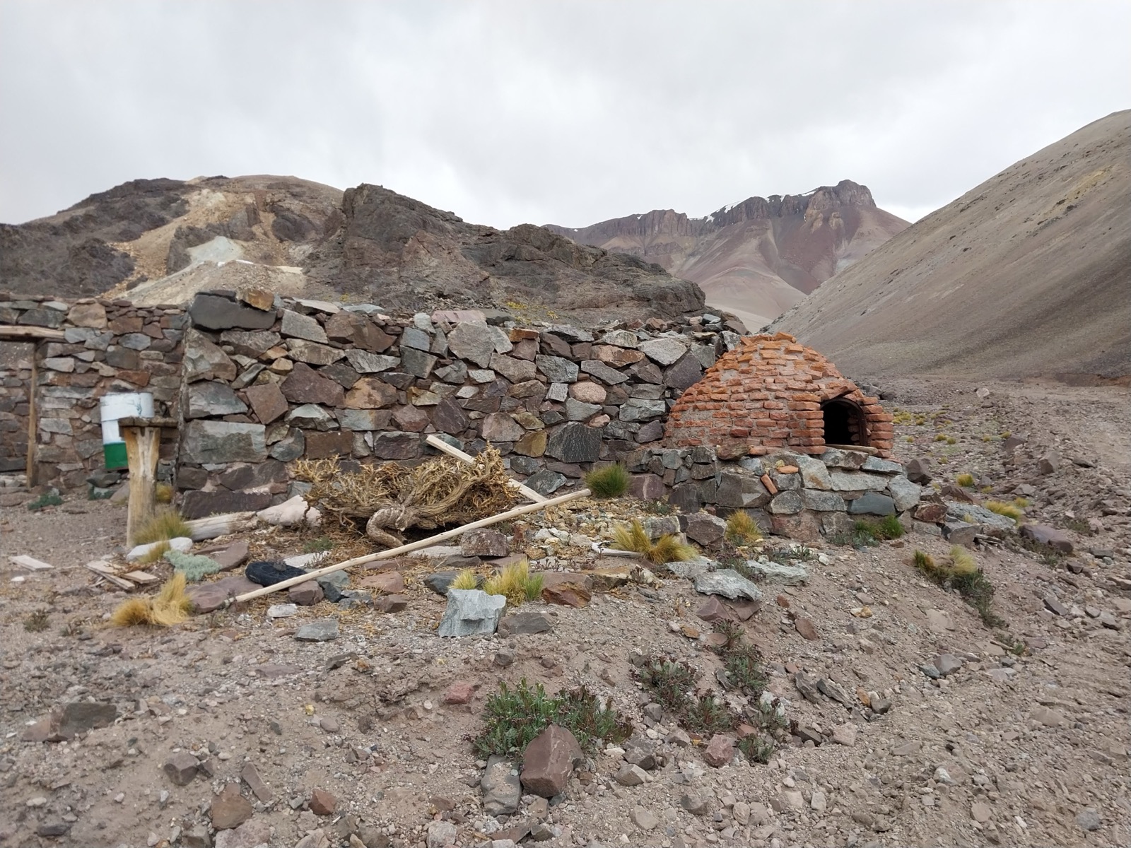
The district was worked artisanally from the late 19th century until the 1960s. Structures from that period remain, such as this stone smelting furnace. Exploration with modern methods began in 2020.

Stone smelting furnace from the former El Fierro mining district
Strategic location

Iglesia Department, San Juan

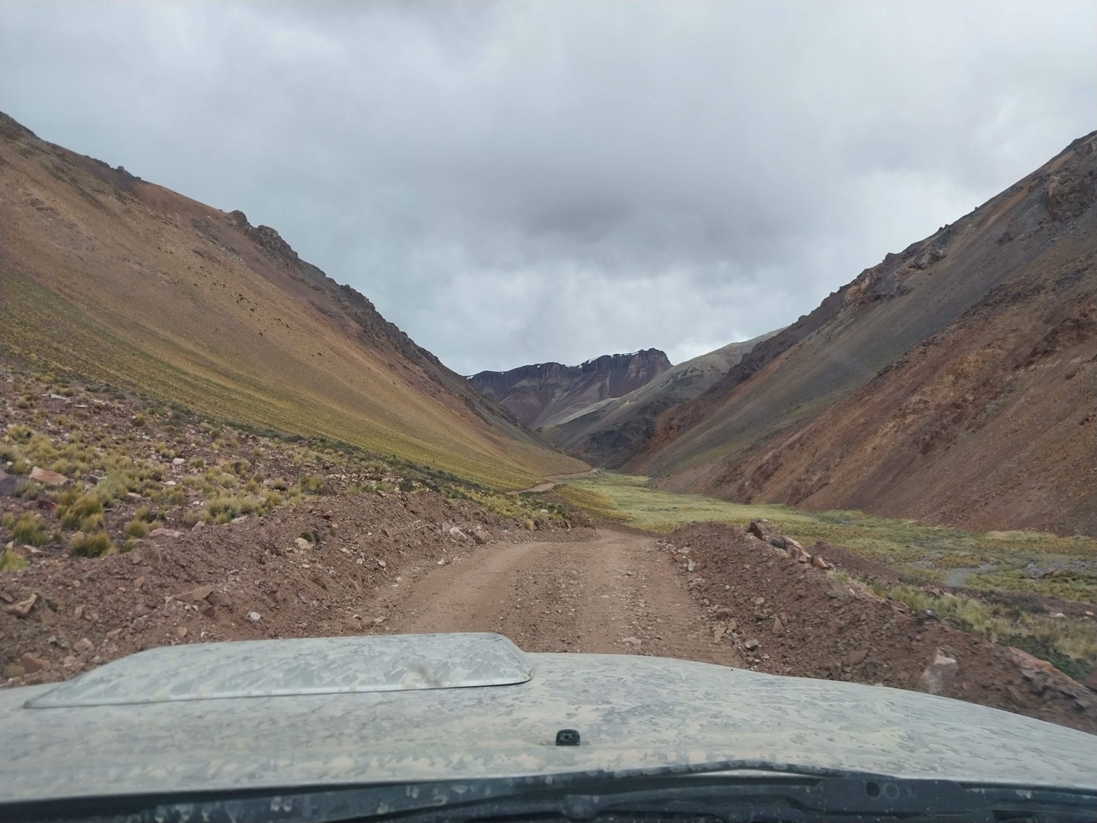
The project is located at the northeastern end of the Colangüil range, in the Cordillera Frontal geological province, about 250 km northwest of the city of San Juan. Access is via an existing road suitable for 4x4 vehicles. The road starts at Route 430, near Angualasto (the last town with services), and runs about 75 km along the El Fierro creek gorge.

Within the rights there is a surveyed network of more than 30 km of internal roads. It connects the Fierro Bajo, Fierro Alto, La Verde and Lagunitas sectors with the base camp site. As a regional reference, El Fierro lies about 45 km east of the Veladero mine and about 105 km south of the Filo del Sol deposit, in a straight line.

Access road to the El Fierro project, Colangüil range
Frequently asked questions

What people usually ask about El Fierro

What is the El Fierro project?

El Fierro is a polymetallic mining project at the exploration stage, in Iglesia Department, San Juan province, Argentina. It comprises ten mining rights owned by the Fuentes Family, covering close to 6,000 hectares, with veins carrying silver, gold, copper, lead and zinc. It is not a producing mine.

Where is it and how do you get there?

At the northeastern end of the Colangüil range, about 250 km northwest of the city of San Juan. Access is via an existing 4x4-capable road that starts at Route 430 near Angualasto and runs about 75 km along the El Fierro creek gorge. In a straight line, it lies about 45 km east of the Veladero mine and about 105 km south of the Filo del Sol deposit.

What kind of mineralization does it have?

Sub-epithermal polymetallic veins with silver, gold, copper, lead and zinc, hosted in Carboniferous metasedimentary rocks and Miocene volcanics and controlled by faults. About 8.8 km of vein traces have been mapped within the rights, and drilling is concentrated at La Verde, Lagunitas, Antena and Fierro Bajo.

How much has been drilled and what grades were returned?

Between 2021 and 2025, 68 diamond drill holes were completed, with 9,944 m drilled within the rights. With ALS laboratory grades, some intervals are 3.70 m @ 11.5 g/t Au and 282 g/t Ag at La Verde (including 0.50 m @ 49.8 g/t Au), 17.7 m @ 58.6 g/t Ag and 2.1% Pb+Zn at Lagunitas, 5.0 m @ 0.71% Cu at Antena and 0.50 m @ 1,290 g/t Ag and 6.9% Pb at Fierro Bajo. These are selected intervals measured along the hole, not the project average.

Who owns the mining rights?

The ten El Fierro mining rights belong to the Fuentes Family. The legal structure and ownership of the rights, and the current acquisition mechanism, are detailed in the Virtual Data Room.

How long has the area been explored?

The Rara Fortuna and Felicidad mines, part of El Fierro, were registered in 1888. The district was worked artisanally from the late 19th century until the 1960s, and exploration with modern methods began in 2020, with geological mapping, sampling, geophysics and diamond drilling.

Is the project available for investment?

El Fierro is offered as an investment opportunity. The terms and the current acquisition mechanism are provided inside the Virtual Data Room, upon access request and signing of a non-disclosure agreement (NDA).

How do I get the full technical and legal information?

By requesting access to the Virtual Data Room with the form on this page. It includes the detailed technical report (geological mapping, geophysics, drill hole tables), the legal structure and ownership, geographic files (KMZ) and the current acquisition mechanism. Access is subject to review and to signing an NDA; once approved, you receive a personal access by email.

Virtual Data Room

Request access to the full technical and legal information

El Fierro's Virtual Data Room includes the detailed technical report (geological mapping, geophysics, drill hole tables), the legal structure and mining rights ownership, geographic files (KMZ) and the current acquisition mechanism. Access is subject to review and to signing a non-disclosure agreement (NDA).

  • Fill out the form with your details.
  • Our team reviews the request and coordinates the NDA signature.
  • Once approved, you will receive a personal Data Room access by email.

Already have approved access? Sign in to the Data Room →

Before enabling Data Room access, we will request by email a copy of the power of attorney, board resolution or other instrument evidencing your authority to sign on behalf of the company.

Your details are used solely to evaluate this request and, if applicable, to draft the non-disclosure agreement (NDA).